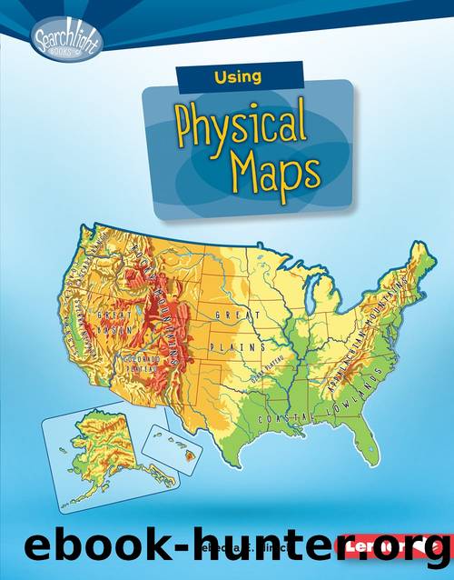
Using Physical Maps by Rebecca E. Hirsch
Author:Rebecca E. Hirsch
Language: eng
Format: epub
ISBN: 9781512485653
Publisher: Lerner Publishing Group, Inc.
Chapter 3
HOW DO YOU USE
A PHYSICAL MAP?
Using a physical map means
knowing how to use its tools and
read its symbols. The scale tool helps
you understand distances on the map. It
shows that a certain distance on the map
stands for a certain distance on Earth.
Scales like this one are often
near the bottom of a map.
What is a scale used for?
Maps have different types of scales. One common
type looks like a ruler. Scales like this are often marked
with miles, kilometers, or both. To use this kind of
scale, line up the edge of a sheet of paper between two
locations on a map. Make a mark on the paper at each
spot. Then move the paper to the scale. Line up one
mark with the zero. The other mark will be on or near a
number that shows the distance.
A scale can help you find the
distance between Honolulu
and Waikiki in Oahu, Hawaii.
Download
This site does not store any files on its server. We only index and link to content provided by other sites. Please contact the content providers to delete copyright contents if any and email us, we'll remove relevant links or contents immediately.
| Atlases | Dictionaries |
| Encyclopedias |
Common Core Math For Parents For Dummies with Videos Online by Christopher Danielson(986)
Grammar Secrets by Caroline Taggart(585)
The Boss of Everyone by Danny Wallace(300)
Learn Russian Language Through Dialogue by Anna Tkachenko(264)
84 Amazing Maths Games to Boggle Your Brain! by Anna Claybourne(252)
Plus Magazine French Edition by F vrier 2023(248)
39 ESL Vocabulary Activities by Jackie Bolen(222)
Bilingual Book in English and Portuguese by Colin Hann(214)
Digital Flash Cards--Times Tables Multiplication Facts by Devi Tan(211)
A Field Guide to Goblins, Gremlins, and Other Wicked Creatures by Colin Ashcroft(208)
Search and Rescue Animals by Precious McKenzie(208)
Using Climate Maps by Rebecca E. Hirsch(204)
Unusual and Awesome Jobs Using Math by Lisa M. Bolt Simons(191)
Channel Runner (Great Stories by Jeremy Taylor(186)
Let's Learn Tagalog Ebook by Imelda Fines Gasmen(184)
Forensic Psychologists by Jason Warr(184)
Fart-o-Pedia by Rip Van Ripperton(178)
Day of the Bizarros! by Benjamin Bird(176)
Hispanic America, Texas, and the Mexican War: 1835 - 1850 by James Lincoln Collier(174)
